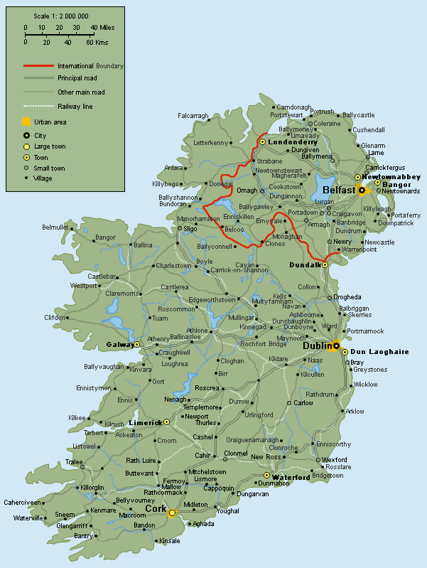
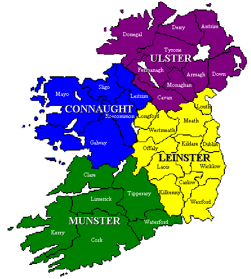
Louth
El Condado de Lú/Louth (Contae Lú en irlandés), (County Louth en inglés) se encuentra en la costa occidental de Irlanda, en la provincia de Leinster. Su nombre quiere decir en irlandés "el menor", y en consecuencia es el condado de menor tamańo de Irlanda. La capital del condado de Lú / Louth es Dún Dealgan (en irlandés) / Dundalk (en inglés).
The county town is Dundalk, which is also the largest town in Louth. The majority of the county's population live in either Dundalk or Drogheda. The 2006 Census confirmed Dundalk and Drogheda as not only the largest towns in the county, but also the second and third largest towns in Ireland.
Drogheda has a population marginally larger than that of Dundalk. This however, includes areas and suburbs of Drogheda which lie in County Meath.
County Louth is affectionately called "the Wee County" being the smallest county in Ireland having a total area of only 821sq kilometres (317sq miles).
Origin of name
The original Irish name of the county Lughbhaidh comes from the place of worship of the Celtic god Lugh whose festival was celebrated at Lúnasa.
The names for both county and village are now spelled as An Lú. This is merely a modern standardised rendering of the older Lughbhaidh. The name has nothing to do with the comparative/superlative form lú meaning smaller or smallest of the adjective beag.
Historia
Este es un condado empapado en el mito, la leyenda y la historia, yendo de nuevo a los días prehistóricos del Táin Bó Cuailgne. El condado vivió más adelante la influencia de los vikingos según lo visto en nombre de Carlingford Lough. En el siglo XIV temprano, derrotaron al ejército escocés de Edward Bruce (hermano de Roberto de la fama de Bannockburn) en la batalla de Faughart cerca de Dundalk, Edward no sólo perdió su demanda al alto Kingship de Irlanda, si no también su vida. Los siglos XVI y XVII ofrecieron muchas escaramuzas y batallas que implicaban las fuerzas irlandesas e inglesas. Oliver Cromwell atacó Drogheda en 1649 derrotando la guarnición de Royalist.

www.gumtree.ie/dublin/65/13818165.html
Omeath - Warrenpoint Passenger Ferry ...
www.discovernorthernireland.com/Warrenpoint-O...
Notable settlements in County Louth
Towns
Ardee - Drogheda - Dundalk - Dunleer - Greenore
Villages
Annagassan - Ballymascanlon - Baltray - Blackrock - Carlingford - Castlebellingham
Clogherhead - Collon - Darver - Dromiskin - Jenkinstown - Kilsaran -Knockbridge
Louth - Mansfieldtown - Omeath - Tallanstown - Termonfeckin - Tullyallen - Tinure
See also
List of abbeys and priories in the Republic of Ireland (County Louth)
External links
Omeath Online - Official Site of Omeath, Co. Louth
Carlingford Online - Carlingford Local and Tourist Site
Dunleer Parish
Louth Local AuthoritiesDrogheda Tourism - Official Site of the Drogheda Tourist Office
O’Hares, Carlingford
Ghan House, Carlingford
Quaglinos at The Century, Dundalk
Festival Whitestown, Carlingford
Blackrock Annual Race Raft
Llegar y viajar en el condado de Louth, Irlanda : Bed Breakfast ...
Vivo Irlanda -- La web de los espańoles que viven o quieren vivir ...
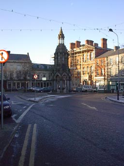
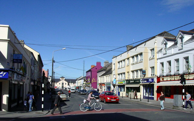
Dundalk (en irlandés: Dún Dealgan) es una ciudad, capital del Condado de Louth en la provincia de Leinster, en el noreste de la República de Irlanda. La ciudad se encuentra aproximadamente en el punto medio entre las ciudades de Dublín y Belfast.
Within legally defined boundaries, Dundalk is officially the largest town in Ireland with a population of 29,037 inhabitants. In 2003, Dundalk was amongst nine cities and towns to be designated Gateway status in the Irish Government's National Spatial Strategy.
History
Infrastructure
Ongoing infrastructure evolutions continue in and around Dundalk to meet a programme deadline of 2020. These improvements embrace the road, rail and telecommunication infrastructures for—according to the National Development Plan—a better integration with the neighbouring Dublin, Midlands Gateway, and Cavan/Monaghan Hubs.
Overview
Dundalk today retains the linear characteristics of a medieval town, although there is evidence of prehistoric and early Christian settlements. The town is now the sixth largest conurbation in the Republic of Ireland in population and is strategically located on the east coast approximately equi-distant between Dublin and Belfast, the two largest cities on the island. The town has a total population of 35,085 (2006 Census). Dundalk Institute of Technology is the town's third level institution. Dundalk is also home to Internet Service ProvidersDigiweb.
Within a 50 kilometres (31 mi) radius there is a population of 428,000. Dundalk is located on the M1Motorway and is also served by the inter-city rail network. Dundalk is very advantageously positioned in relation to international airports, Dublin International Airport and Belfast International Airport.
External links
Dundalk Chamber of Commerce
Dundalk Town Council
Architecture of Dundalk
(Wikipedia)
County Museum - Dundalk
Located at Jocelyn Street, Dundalk, in a beautifully restored late 18th century warehouse, the County Museum hosts a wide variety of events and activities. The County Museum tells the story of Louth's archaeological, social, natural and industrial heritage. The displays present the origins and evolution of the County from the Mesolithic period to the present day.
Holy Trinity Heritage Centre - Carlingford
Located at Old Quay Lane, Carlingford, in a restored medieval church, the Holy Trinity Centre houses exhibits which detail the development of the town from its Norman origins through the use of Video presentations. From the centre the street and monuments of this ancient place can be explored.
Millmount Museum - Droghedra
Located in Drogheda in the Officer's Quarters of a former military barracks built in 1808, the museum has been described as one of the finest town museums in Ireland. The Museum houses a wide variety of artifacts of local and national importance. Popular exhibits include an authentic 18th century Irish Folk Kitchen, Dairy and Laundry, and the Irish History Room detailing the major events in Ireland's history.
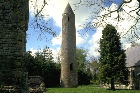
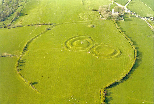
Located at Collon, Monasterboice is known for its remains of the monastic settlement founded by Saint Buite in the fifth century. The remains consist of an old graveyard, two churches, three sculptured crosses, two early grave slabs and a sundial. The South church is the older of the two and it still has the remains of the chancel arch. The smaller church is situated beside the Round Tower and has no trace of a chancel. The Round Tower is about 100ft high.
Proleek Dolmen - Proleek
Located in the grounds of Ballymascanlon Hotel, this is a fine example of a Portal Dolmen. The capstone which weighs about 40 tons is supported by three legs. Legend has it that a wish will be granted to those who can throw a pebble on to the top of the capstone so that it stays there. There is a wedge tomb in the same field.
Saint Peter's Church - Droghedra
Located at West Street, Drogheda, Saint Peter's Church is one of the finest Gothic Revival churches in Ireland. The interior has been extensively restored in recent years. The church was built as a memorial to Oliver Plunkett, a 17th century Archbishop of Armagh who was martyred at Tyburn in 1691.
Heritage Sites
Old Mellifont Abbey - Droghedra
The first Cistercian monastery in Ireland founded in 1142 by St. Malachy of Armagh, its most unusual feature is the octagonal Lavabo c.1200. The Visitor Centre houses an interesting exhibition on the work of masons in the Middle Ages with fine examples of their craft on display.
Abadía de Old Mellifont
Elemento central del pasado de Irlanda, Louth está lleno de antiguas reliquias y monumentos, mientras que el paisaje del norte, alrededor de la bella Península Cooley está repleto de leyendas, mitos y cuentos tradicionales.
La ciudad patrimonio de Carlingford se sitúa a los pies de la exuberante Montańa Slieve Foy, al borde del Lago Carlingord, lo que confiere a esta ciudad medieval un encanto natural inigualable.
Dundalk, por su parte, es una impresionante y animada ciudad con excelentes museos y una gran selección de tiendas, bares y restaurantes.
(discoverireland.com)
Wildcamp
MARKET RASEN
Between Market Rase & Louth on the A 631 just after the racecourse is a picnic area with two car parks if you are narrow enough to get through the two large rocks into the second park. This is the best place because you are not disturbed by the hgv´s.
GPS 53* 22´49,2" N, 0* 17´ 29,0 " W.
)))))))))))))))))))))))))))))))))))))))))))))))))) )))))))))))))))))))))))))))))))))))))))))))))))))) )))))))))))))))))))))))))))))))))))))))))))))))))) )))))))))))))))))))))))))))))))))))))))))))))))))) ))))
7. Condado: Louth - Capital: Dundalk
Provincia: Leinster - Superficie: 820 km˛ - Población: ~ 105.000 - www.louthcoco.ie

Select a Town
www.countylouth.com/louth_map.htm - < Click on the Map to select a town
Ardee - Ballymascanlon - Blackrock - Carlingford - Castlebellingham - Clogherhead - Collon - Drogheda - Dromiskin - Dundalk - Dunleer - Greenore - Jenkinstown - Louth - Mansfieldtown - Omeath -Termonfeckin

Lacy bridge Drogheda
7. Condado: Louth - Capital: Dundalk
Provincia: Leinster - Superficie: 820 km˛ - Población: ~ 105.000 - www.louthcoco.ie
Select a Town
www.countylouth.com/louth_map.htm - < Click on the Map to select a town
Ardee - Ballymascanlon - Blackrock - Carlingford - Castlebellingham - Clogherhead - Collon - Drogheda - Dromiskin - Dundalk - Dunleer - Greenore - Jenkinstown - Louth - Mansfieldtown - Omeath -Termonfeckin
Lacy bridge Drogheda
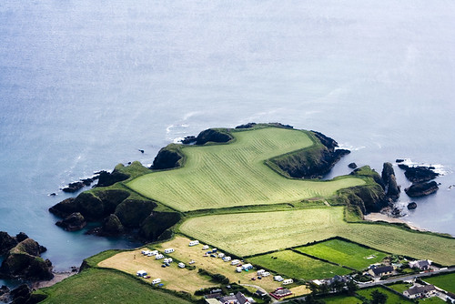
Louth, the smallest county in Ireland and known affectionately as the "Wee County" runs northwards from Drogheda on the River Boyne to the medieval town of Carlingford with King John's Castle and the beautiful Carlingford Lough. Louth consists mainly of fertile surging country with a coastline of sandy bays and occasional rocky headlands. In the North, between Dundalk Bay and Carlingford Lough, is the mountainous Cooley Peninsula, and it is here that the legend of the Cattle Raid of Cooley lives on. Its wild and powerful landscape is a fitting location for this epic.
Despite being the smallest county in Ireland by land area, Louth is densely populated. It's two main towns, Drogheda and Dundalk comprise a population of approximately 70,000 people and both are currently rapidly expanding because of their proximity to Dublin and the completion of the M1 motorway. The improved road infrastructure, together with an excellent main line railway network, has made them ideal towns for commuters working in Dublin.
Ardee is Louth's third town, located on the N2. This a much smaller market town, with a population of some 4,000 people. Another small town that is growing rapidly is the mid louth town of Dunleer.
There is a wide range of Accommodation in Louth from Castles , Hotels , B&B's and with plenty of restaurants and pubs for lively entertainment.

www.jackiewoods.com/views_of_carlingford.html
Views Of Carlingford - How To Get Here - Nature In Carlingford
Despite being the smallest county in Ireland by land area, Louth is densely populated. It's two main towns, Drogheda and Dundalk comprise a population of approximately 70,000 people and both are currently rapidly expanding because of their proximity to Dublin and the completion of the M1 motorway. The improved road infrastructure, together with an excellent main line railway network, has made them ideal towns for commuters working in Dublin.
Ardee is Louth's third town, located on the N2. This a much smaller market town, with a population of some 4,000 people. Another small town that is growing rapidly is the mid louth town of Dunleer.
There is a wide range of Accommodation in Louth from Castles , Hotels , B&B's and with plenty of restaurants and pubs for lively entertainment.
www.jackiewoods.com/views_of_carlingford.html
Views Of Carlingford - How To Get Here - Nature In Carlingford
El Condado de Lú/Louth (Contae Lú en irlandés), (County Louth en inglés) se encuentra en la costa occidental de Irlanda, en la provincia de Leinster. Su nombre quiere decir en irlandés "el menor", y en consecuencia es el condado de menor tamańo de Irlanda. La capital del condado de Lú / Louth es Dún Dealgan (en irlandés) / Dundalk (en inglés).
The county town is Dundalk, which is also the largest town in Louth. The majority of the county's population live in either Dundalk or Drogheda. The 2006 Census confirmed Dundalk and Drogheda as not only the largest towns in the county, but also the second and third largest towns in Ireland.
Drogheda has a population marginally larger than that of Dundalk. This however, includes areas and suburbs of Drogheda which lie in County Meath.
County Louth is affectionately called "the Wee County" being the smallest county in Ireland having a total area of only 821sq kilometres (317sq miles).
Origin of name
The original Irish name of the county Lughbhaidh comes from the place of worship of the Celtic god Lugh whose festival was celebrated at Lúnasa.
The names for both county and village are now spelled as An Lú. This is merely a modern standardised rendering of the older Lughbhaidh. The name has nothing to do with the comparative/superlative form lú meaning smaller or smallest of the adjective beag.
Historia
Este es un condado empapado en el mito, la leyenda y la historia, yendo de nuevo a los días prehistóricos del Táin Bó Cuailgne. El condado vivió más adelante la influencia de los vikingos según lo visto en nombre de Carlingford Lough. En el siglo XIV temprano, derrotaron al ejército escocés de Edward Bruce (hermano de Roberto de la fama de Bannockburn) en la batalla de Faughart cerca de Dundalk, Edward no sólo perdió su demanda al alto Kingship de Irlanda, si no también su vida. Los siglos XVI y XVII ofrecieron muchas escaramuzas y batallas que implicaban las fuerzas irlandesas e inglesas. Oliver Cromwell atacó Drogheda en 1649 derrotando la guarnición de Royalist.
www.gumtree.ie/dublin/65/13818165.html
Omeath - Warrenpoint Passenger Ferry ...
www.discovernorthernireland.com/Warrenpoint-O...
Notable settlements in County Louth
Towns
Ardee - Drogheda - Dundalk - Dunleer - Greenore
Villages
Annagassan - Ballymascanlon - Baltray - Blackrock - Carlingford - Castlebellingham
Clogherhead - Collon - Darver - Dromiskin - Jenkinstown - Kilsaran -Knockbridge
Louth - Mansfieldtown - Omeath - Tallanstown - Termonfeckin - Tullyallen - Tinure
See also
List of abbeys and priories in the Republic of Ireland (County Louth)
External links
Omeath Online - Official Site of Omeath, Co. Louth
Carlingford Online - Carlingford Local and Tourist Site
Dunleer Parish
Louth Local AuthoritiesDrogheda Tourism - Official Site of the Drogheda Tourist Office
O’Hares, Carlingford
Ghan House, Carlingford
Quaglinos at The Century, Dundalk
Festival Whitestown, Carlingford
Blackrock Annual Race Raft
Llegar y viajar en el condado de Louth, Irlanda : Bed Breakfast ...
Vivo Irlanda -- La web de los espańoles que viven o quieren vivir ...
)))))))))))))))))))))))))))))))))))))))))))))))))) )))))))))))))))))))))))))))))))))))))))))))))))))) )))))))))))))))))))))))))))))))))))))))))))))))))) )))))))))))))))))))))))))))))))))))))))))))))))))) ))))
Capital: Dundalk
Interactive Map of Dundalk, County Louth, Ireland
Coordinates: 54°00′00″ N 6°24′13″ W
commons.wikimedia.org/wiki/Image:05_de_Lacy_b...
Capital: Dundalk
Interactive Map of Dundalk, County Louth, Ireland
Coordinates: 54°00′00″ N 6°24′13″ W
commons.wikimedia.org/wiki/Image:05_de_Lacy_b...
Welcome to County Louth

County Louth is located on the east coast of Ireland and belongs to the province of Leinster. It covers an area of 820 km˛ and is Ireland's smallest county. It is bordered by the Irish Sea and Northern Ireland. The capital is Dundalk and most of the county's population lives in this great industrial town. The mountainous Cooley Peninsula can be found in the north of the county. It is one of the finest scenic areas on the east coast located between Dundalk Bay and Carlingford Lough. Located on the south side of Carlingford Lough there are the Cooley Mountains with the Mourne Mountains rising from the north. Another important town in county Louth is Drogheda. The ancient and historic town is situated on the river Boyne. This river separates the counties Louth and Meath. The city is an important industrial centre and has a port with a nice harbour.
www.louth-bnb.com/
www.discoverireland.com/.../?fid=FI_68902
Dundalk (en irlandés: Dún Dealgan) es una ciudad, capital del Condado de Louth en la provincia de Leinster, en el noreste de la República de Irlanda. La ciudad se encuentra aproximadamente en el punto medio entre las ciudades de Dublín y Belfast.
))))))))))))))))))))))))))))))))))))))))))))))))))
It takes its name from Dún Dealgan, Dalga's fort home closely associated with the famous mythical warrior Cúchulainn, and was granted its charter in 1189. It is sited on the lowest bridging point of the Castletown River. The town's crest reads "Mé do rug Cú Chulainn Cróga" (I gave birth to brave Cú Chulainn).Within legally defined boundaries, Dundalk is officially the largest town in Ireland with a population of 29,037 inhabitants. In 2003, Dundalk was amongst nine cities and towns to be designated Gateway status in the Irish Government's National Spatial Strategy.
History

Infrastructure
Ongoing infrastructure evolutions continue in and around Dundalk to meet a programme deadline of 2020. These improvements embrace the road, rail and telecommunication infrastructures for—according to the National Development Plan—a better integration with the neighbouring Dublin, Midlands Gateway, and Cavan/Monaghan Hubs.
Overview
Dundalk today retains the linear characteristics of a medieval town, although there is evidence of prehistoric and early Christian settlements. The town is now the sixth largest conurbation in the Republic of Ireland in population and is strategically located on the east coast approximately equi-distant between Dublin and Belfast, the two largest cities on the island. The town has a total population of 35,085 (2006 Census). Dundalk Institute of Technology is the town's third level institution. Dundalk is also home to Internet Service ProvidersDigiweb.
Within a 50 kilometres (31 mi) radius there is a population of 428,000. Dundalk is located on the M1Motorway and is also served by the inter-city rail network. Dundalk is very advantageously positioned in relation to international airports, Dublin International Airport and Belfast International Airport.
External links
Dundalk Chamber of Commerce
Dundalk Town Council
Architecture of Dundalk
(Wikipedia)
))))))))))))))))))))))))))))))))))))))))))))))))))

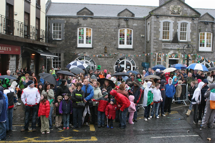
Drogheda
))))))))))))))))))))))))))))))))))))))))))))))))))
Main Tourist Attractions
Drogheda
))))))))))))))))))))))))))))))))))))))))))))))))))
County Museum - Dundalk
Located at Jocelyn Street, Dundalk, in a beautifully restored late 18th century warehouse, the County Museum hosts a wide variety of events and activities. The County Museum tells the story of Louth's archaeological, social, natural and industrial heritage. The displays present the origins and evolution of the County from the Mesolithic period to the present day.
Holy Trinity Heritage Centre - Carlingford
Located at Old Quay Lane, Carlingford, in a restored medieval church, the Holy Trinity Centre houses exhibits which detail the development of the town from its Norman origins through the use of Video presentations. From the centre the street and monuments of this ancient place can be explored.
Millmount Museum - Droghedra
Located in Drogheda in the Officer's Quarters of a former military barracks built in 1808, the museum has been described as one of the finest town museums in Ireland. The Museum houses a wide variety of artifacts of local and national importance. Popular exhibits include an authentic 18th century Irish Folk Kitchen, Dairy and Laundry, and the Irish History Room detailing the major events in Ireland's history.
))))))))))))))))))))))))))))))))))))))))))))))))))

It was here in Drogheda that we also had our first encounter with another of Ireland's great architectural icons: the Guinness sign! There are a seemingly endless variety of them, since almost every pub has their own Guinness sign . . . and there are a LOT of pubs in Ireland!
storeysisters.net/.../week1_page1.html
Grandes Cruces y Torre Circular de Monasterboicer, cerca de Drogheda
))))))))))))))))))))))))))))))))))))))))))))))))))
Monasterboice - CollonIt was here in Drogheda that we also had our first encounter with another of Ireland's great architectural icons: the Guinness sign! There are a seemingly endless variety of them, since almost every pub has their own Guinness sign . . . and there are a LOT of pubs in Ireland!
storeysisters.net/.../week1_page1.html
Grandes Cruces y Torre Circular de Monasterboicer, cerca de Drogheda
))))))))))))))))))))))))))))))))))))))))))))))))))
Located at Collon, Monasterboice is known for its remains of the monastic settlement founded by Saint Buite in the fifth century. The remains consist of an old graveyard, two churches, three sculptured crosses, two early grave slabs and a sundial. The South church is the older of the two and it still has the remains of the chancel arch. The smaller church is situated beside the Round Tower and has no trace of a chancel. The Round Tower is about 100ft high.
Proleek Dolmen - Proleek
Located in the grounds of Ballymascanlon Hotel, this is a fine example of a Portal Dolmen. The capstone which weighs about 40 tons is supported by three legs. Legend has it that a wish will be granted to those who can throw a pebble on to the top of the capstone so that it stays there. There is a wedge tomb in the same field.
Saint Peter's Church - Droghedra
Located at West Street, Drogheda, Saint Peter's Church is one of the finest Gothic Revival churches in Ireland. The interior has been extensively restored in recent years. The church was built as a memorial to Oliver Plunkett, a 17th century Archbishop of Armagh who was martyred at Tyburn in 1691.
Heritage Sites
Old Mellifont Abbey - Droghedra
The first Cistercian monastery in Ireland founded in 1142 by St. Malachy of Armagh, its most unusual feature is the octagonal Lavabo c.1200. The Visitor Centre houses an interesting exhibition on the work of masons in the Middle Ages with fine examples of their craft on display.
Abadía de Old Mellifont
)))))))))))))))))))))))))))))))))))))))))))))))))) )))))))))))))))))))))))))))))))))))))))))))))))))) )))))))))))))))))))))))))))))))))))))))))))))))))) )))))))))))))))))))))))))))))))))))))))))))))))))) ))))
Definitivamente pequeńo es sinónimo de bello cuando se trata del chiquito condado de Louth
El pequeńo pero perfectamente formado condado de Louth en la costa este de Irlanda ocupa tan sólo 500km2, pero está lleno de atracciones excepcionales, desde maravillosos paisajes alrededor del Lago de Carlingford, hasta el histórico Valle Boyne. Definitivamente pequeńo es sinónimo de bello cuando se trata del chiquito condado de Louth
Elemento central del pasado de Irlanda, Louth está lleno de antiguas reliquias y monumentos, mientras que el paisaje del norte, alrededor de la bella Península Cooley está repleto de leyendas, mitos y cuentos tradicionales.
La ciudad patrimonio de Carlingford se sitúa a los pies de la exuberante Montańa Slieve Foy, al borde del Lago Carlingord, lo que confiere a esta ciudad medieval un encanto natural inigualable.
Dundalk, por su parte, es una impresionante y animada ciudad con excelentes museos y una gran selección de tiendas, bares y restaurantes.
(discoverireland.com)
)))))))))))))))))))))))))))))))))))))))))))))))))) )))))))))))))))))))))))))))))))))))))))))))))))))) )))))))))))))))))))))))))))))))))))))))))))))))))) )))))))))))))))))))))))))))))))))))))))))))))))))) ))))
Countryside Motorhomes -Wildcamp
MARKET RASEN
Between Market Rase & Louth on the A 631 just after the racecourse is a picnic area with two car parks if you are narrow enough to get through the two large rocks into the second park. This is the best place because you are not disturbed by the hgv´s.
GPS 53* 22´49,2" N, 0* 17´ 29,0 " W.
)))))))))))))))))))))))))))))))))))))))))))))))))) )))))))))))))))))))))))))))))))))))))))))))))))))) )))))))))))))))))))))))))))))))))))))))))))))))))) )))))))))))))))))))))))))))))))))))))))))))))))))) ))))
Index MUND TEKA 1 : página 1, post 1
)))))))))))))))))))))))))))))))))))))))))))))))))) )))))))))))))))))))))))))))))))))))))))))))))))))) )))))))))))))))))))))))))))))))))))))))))))))))))) )))))))))))))))))))))))))))))))))))))))))))))))))) ))))
Index MUND
TEKA 1 : página 1, post 1)))))))))))))))))))))))))))))))))))))))))))))))))) )))))))))))))))))))))))))))))))))))))))))))))))))) )))))))))))))))))))))))))))))))))))))))))))))))))) )))))))))))))))))))))))))))))))))))))))))))))))))) ))))


Comentario