Irlanda
Irlanda (Éire [ˈeːrʲə], en irlandés; Ireland, en inglés), es un país del noroeste de Europa que forma parte de la Unión Europea (UE). Su capital es Dublín (en irlandés: Baile Átha Cliath y en inglés: Dublin). En el ańo 1949 se declara el estado irlandés como la República de Irlanda (en inglés Republic of Ireland, en irlandés: Poblacht na hÉireann). A veces se le llama coloquialmente «la Isla Esmeralda», haciendo referencia al intenso color verde de los campos irlandeses.
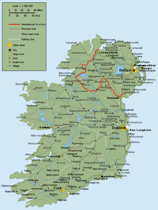
La isla de Irlanda es por su tamańo la tercera isla de Europa, y la vigésima del mundo. Está situada al noroeste de Europa Continental, en el lado occidental del Mar de Irlanda, al oeste de la isla de Gran Bretańa, y se encuentra rodeada por centenares de islas menores e islotes. Dos países poseen soberanía sobre la isla, la República de Irlanda, un país independiente, que ocupa aproximadamente cinco sextas partes de la isla, e Irlanda del Norte, una región administrativa del Reino Unido, que ocupa la sexta parte restante, en el extremo nororiental de la isla.
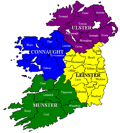
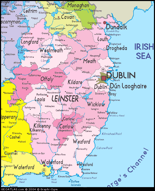
Su territorio abarca aproximadamente cinco sextos de la isla (la occidental de las llamadas Islas Británicas), contra la costa del noroeste de Europa. El sexto restante pertenece a Irlanda del Norte, una región administrativa del Reino Unido y parte de la provincia irlandesa histórica del Ulster. Está tradicionalmente dividida en cuatro regiones o provincias: Leinster (irlandés: Laighin), Ulster (irlandés: Cúige Uladh), Connacht (irlandés: Connachta) y Munster (irlandés: An Mhumhain).
Organización político-administrativa
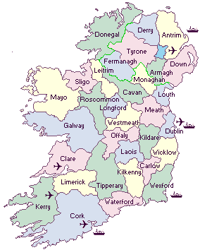
La República de Irlanda consta de 26 condados, los cuales continúan siendo utilizados en contextos culturales, históricos y deportivos. De acuerdo a un estatuto, los distritos electorales del Dáil deben ir conforme los límites de los condados. Por esta razón, aquellos con una mayor población tienen múltiples distritos electorales (por ejemplo, el Limerick del este y oeste), y algunos distritos electorales consisten de más de un condado (por ejemplo Sligo-Leitrim), pero en términos generales los límites de los condados no se suelen cruzar.
Sin embargo, como unidades de gobierno locales, algunos han sido reestructurados: así, Tipperary se dividió administrativamente en dos condados en los ańos 1890, y el condado de Dublín fue disgregado en tres nuevos "county councils" (consejos de condado) durante los ańos 1990, con lo cual ahora existen 29 condados administrativos. Además, las cinco ciudades (Dublín, Cork, Galway, Limerick y Waterford) se administran separadamente, y cinco municipios (Clonmel, Drogheda, Kilkenny, Sligo y Wexford) tienen una cierta autonomía dentro de sus condados respectivos.

Cliquear para agrandarGeografía
La isla de Irlanda se ubica al noroeste de Europa, formando parte del archipiélago británico siendo la segunda isla en extensión del mismo, es la tercera isla de Europa, después de Gran Bretańa e Islandia, y la vigésima del mundo.
La superficie de la isla es de 84.421 km˛, de los cuales un 83% (aprox. cinco sextos) pertenecen a la República (70 280 km˛) y el resto constituyen Irlanda del Norte. Está rodeada al oeste por el Océano Atlántico, al Noreste por el Canal del Norte. Al este se encuentra el Mar de Irlanda el cual conecta el océano vía suroeste, con el Canal de San Jorge y el Mar Celta. La costa oeste de Irlanda está formada en su mayor parte por acantilados y montańas bajas (el punto más alto es el Carrauntoohill de 1.041 m).
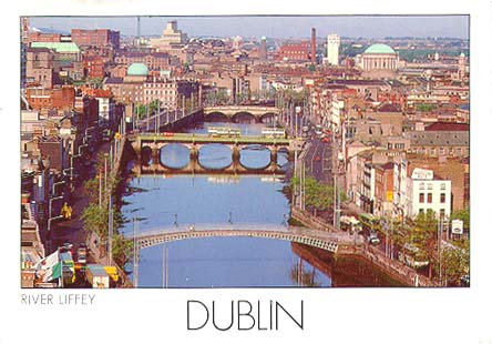
El interior del país es relativamente llano presentando una cuenca deprimida interna y mayores elevaciones en las proximidades de las costas, el territorio es atravesado por ríos como el Shannon presentando muchos y relativamente grandes y poco profundos lagos (loughs). El centro del país está bańado en parte por el río Shannon, y contiene grandes áreas de ciénagas, usadas para la extracción y producción de turba. Irlanda posee el mayor parque natural adosado a ciudad más grande de Europa, el Parque Fénix, el cual mide 712 hectáreas y consta de una circunferencia vallada de 16 kilómetros de extensas zonas verdes y avenidas de árboles en hilera.
Su geografía se encuentra accidentada por los montes Donegal, Wicklow, Mourne, Mac Gillycuddys Reeks y principalmente por su cumbre más alta: el Carrantuonhill (1.041 metros). Además posee numerosos lagos entre los que destacan el Neah, el Lago Erne y el Corrib. Los ríos más importantes son el Shannon, el Blackwater, el Barrow y el Bann. Las costas que circundan la isla suelen ser muy recortadas, altas, con bahías estrechas que presentan semejanzas con las rías y los fiordos; son los firths; las avanzadas de los firths concluyen en importantes penínsulas, especialmente al oeste.
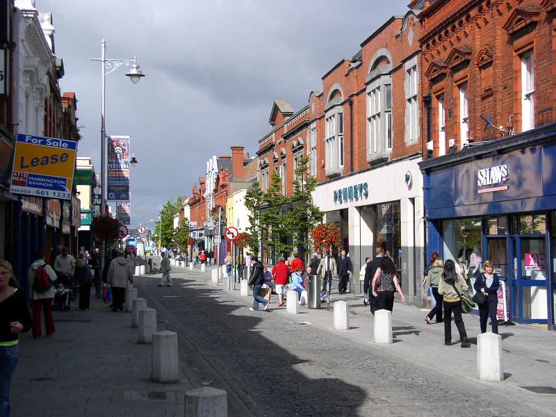
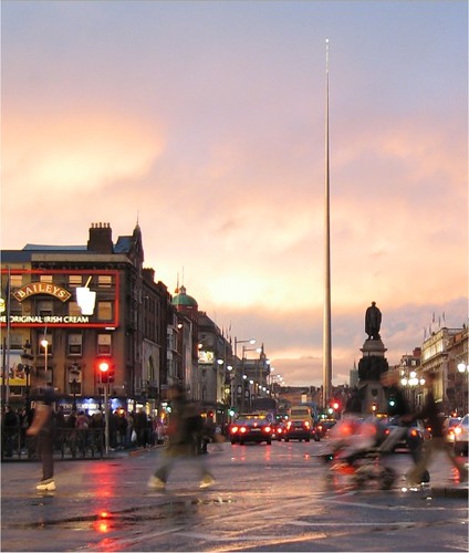
Las temperaturas de la zona son modificadas por el Frente Atlántico norte y es relativamente suave. Los veranos son raramente muy cálidos (las temperaturas solo exceden los 30 °C una vez cada 10 ańos, aunque suelen alcanzar los 29 °C muchos veranos, solo hiela ocasionalmente en invierno (temperaturas inferiores a –6 °C no son comunes). Las precipitaciones son frecuentes, con más de 275 días de lluvia en muchas partes del país. Las principales ciudades son la capital Dublín en la costa este, Cork en el sur, Limerick, Galway en la costa oeste, y Waterford en la costa sureste.
Idioma
Los idiomas oficiales son el irlandés (Gaeilge), idioma celta nativo, y el inglés, el cual es descrito constitucionalmente como un idioma oficial secundario. Aprender irlandés es obligatorio en la educación, pero el inglés es ampliamente predominante. Las seńales públicas son generalmente bilingües y existen también medios nacionales en irlandés. La población perteneciente a comunidades de habla predominantemente irlandesa (los Gaeltacht) se encuentra limitada a apenas unas decenas de miles de personas en bolsas aisladas, principalmente hacia la costa occidental.
Gastronomía
Ejemplos de algunos platos típicos de la cocina irlandesa son el Irish stew, y también el bacon con col (hervidos juntos). El Boxty es un plato tradicional. En Dublín es muy popular el coddle, que se elabora con salchichas de carne de cerdo cocida. En Irlanda es famoso el desayuno irlandés, que se sirve principalmente con carne de cerdo y puede incluir fried potato farls.
Una de las bebidas más asociadas con Irlanda es la Guinness que se suele servir en los pubs, aunque también es popular la Smithwicks (que en el continente europeo se suele conocer como Kilkenny). Está siempre presente la tradición celta de tomar sidra, además del Whisky de malta y el café irlandés. Desde 1974, Irlanda produce uno de los licores más afamados, la Crema irlandesa Baileys, consistente en una mezcla de crema de leche con whisky irlandés, cuyo contenido alcohólico es de un 17% del volumen.

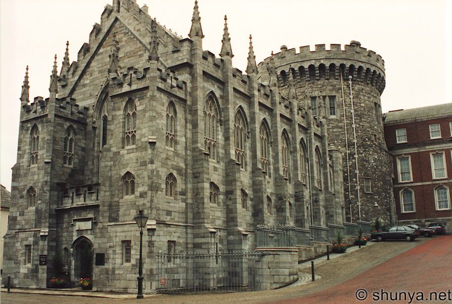
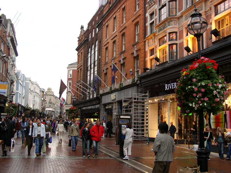
Temple Bar (Irish: Barra an Teampaill) is an area on the south bank of the River Liffey in central Dublin, Ireland. Unlike the areas surrounding it, Temple Bar has preserved its medieval street pattern, with many narrow cobbled streets. It is promoted as "Dublin's cultural quarter" and has a lively nightlife that is popular with tourists. Temple Bar is in the postcode Dublin 2 (D2), and has an estimated population of 3,000.
Coordenadas: 53° 20′ 44″ N, 6° 15′ 46″ W
Temple Bar, Dublin - Wikipedia, the free encyclopedia
travel.webshots.com/photo/1412289769063635817...Véase también
Portal:Irlanda Contenido relacionado con Irlanda.
Día de San Patricio
Bloomsday
Nobles de Irlanda
Enlaces externos
Wikimedia Commons/Irlanda
Wikinoticias /Irlanda
Gobierno de Irlanda
Ministerio de Asuntos Exteriores de Irlanda
Embajada de Espańa en Irlanda
Presidencia irlandesa de la Unión Europea en 2004
Información de la OMS sobre Irlanda
Un viaje por Irlanda
Browse Ireland - Directorio
Guía de viajes de Irlanda


Coordenadas Dublín: 53° 26' N 6° 15' - Ciudad más poblada: Dublín
Idiomas oficiales: Irlandés, inglés -Forma de gobierno: República
Independencia del Reino Unido: 21 de enero de 1919 - Superficie: 70.273 km2
Fronteras: 360 km - Población: ~ 4,1 millones - Moneda: Euro - Prefijo tel.: +353
Densidad: ~ 57 hab/km2
Idiomas oficiales: Irlandés, inglés -Forma de gobierno: República
Independencia del Reino Unido: 21 de enero de 1919 - Superficie: 70.273 km2
Fronteras: 360 km - Población: ~ 4,1 millones - Moneda: Euro - Prefijo tel.: +353
Densidad: ~ 57 hab/km2
Irlanda (Éire [ˈeːrʲə], en irlandés; Ireland, en inglés), es un país del noroeste de Europa que forma parte de la Unión Europea (UE). Su capital es Dublín (en irlandés: Baile Átha Cliath y en inglés: Dublin). En el ańo 1949 se declara el estado irlandés como la República de Irlanda (en inglés Republic of Ireland, en irlandés: Poblacht na hÉireann). A veces se le llama coloquialmente «la Isla Esmeralda», haciendo referencia al intenso color verde de los campos irlandeses.
La isla de Irlanda es por su tamańo la tercera isla de Europa, y la vigésima del mundo. Está situada al noroeste de Europa Continental, en el lado occidental del Mar de Irlanda, al oeste de la isla de Gran Bretańa, y se encuentra rodeada por centenares de islas menores e islotes. Dos países poseen soberanía sobre la isla, la República de Irlanda, un país independiente, que ocupa aproximadamente cinco sextas partes de la isla, e Irlanda del Norte, una región administrativa del Reino Unido, que ocupa la sexta parte restante, en el extremo nororiental de la isla.
Su territorio abarca aproximadamente cinco sextos de la isla (la occidental de las llamadas Islas Británicas), contra la costa del noroeste de Europa. El sexto restante pertenece a Irlanda del Norte, una región administrativa del Reino Unido y parte de la provincia irlandesa histórica del Ulster. Está tradicionalmente dividida en cuatro regiones o provincias: Leinster (irlandés: Laighin), Ulster (irlandés: Cúige Uladh), Connacht (irlandés: Connachta) y Munster (irlandés: An Mhumhain).
Etimología - Historia - Geografía política - Geología - Clima - Flora - Fauna - EconomíaDemografía - Inmigración - Cultura - Literatura - Sociedad - ReligiónCine - Música - Mitología

Lugares de Interés en Irlanda
Todos los destinos
Atracciones Irlanda (353)
Aeropuerto/Estación/Puerto Irlanda
Balneario/Spa Irlanda
Calle peatonal/Calle de compras Irlanda
Campo de golf Irlanda
Casino Irlanda
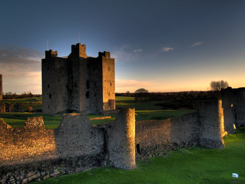
Castillo/Murallas/Palacio Irlanda
Catedral/Iglesia/Monasterio Irlanda
Cicloturismo Irlanda
Cine Irlanda
Discoteca/Club Irlanda
Edificio emblemático Irlanda

www.airportdirecttravel.co.uk/.../Default.aspx

Lugares de Interés en Irlanda
Todos los destinos
Atracciones Irlanda (353)
Aeropuerto/Estación/Puerto Irlanda
Balneario/Spa Irlanda
Calle peatonal/Calle de compras Irlanda
Campo de golf Irlanda
Casino Irlanda
Castillo/Murallas/Palacio Irlanda
Catedral/Iglesia/Monasterio Irlanda
Cicloturismo Irlanda
Cine Irlanda
Discoteca/Club Irlanda
Edificio emblemático Irlanda
www.airportdirecttravel.co.uk/.../Default.aspx
Estación de esquí Irlanda
Excursión en barca Irlanda
Fiestas/Eventos Irlanda
Instalaciones deportivas/Estadio Irlanda
Local/ Bar Irlanda
Mirador Irlanda
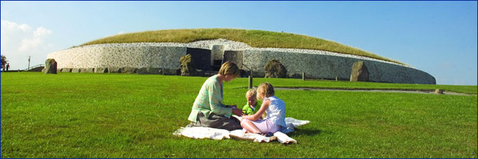
Monumento Irlanda

www.educationireland.no/
Excursión en barca Irlanda
Fiestas/Eventos Irlanda
Instalaciones deportivas/Estadio Irlanda
Local/ Bar Irlanda
Mirador Irlanda
Monumento Irlanda
www.educationireland.no/
Monumento natural Irlanda
Museo/Exposición/Galería de arte Irlanda
Otros sitios de interés Irlanda
Paraje natural Irlanda
Parque de atracciones Irlanda
Parque/Jardín botánico Irlanda
Pista para correr Irlanda
Playa Irlanda
Restaurante Irlanda
Ruta guiada por la ciudad Irlanda
Rutas a pie / escalada Irlanda
Submarinismo Irlanda
Teatro/Ópera Irlanda
Tiendas Irlanda
Windsurf Irlanda
Zoológico/Acuario Irlanda
 -
-
Republic of Ireland - www.buyimage.co.uk/ireland/
1. Dublin - 2. Wicklow - 3. Wexford - 4. Carlow - 5. Kildare - 6. Meath - 7. Louth - 8. Monaghan
9. Cavan - 10. Longford - 11. Westmeath - 12. Offaly - 13. Laois - 14. Kilkenny - 15. Waterford
16. Cork - 17. Kerry 18. Limerick - 19. Tipperary - 20. Clare - 21. Galway - 22. Mayo - 23. Roscommon
24. Sligo - 25. Leitrim - 26. Donegal
Northern Ireland
1. Fermanagh - 2. Tyrone - 3. Derry - 4. Antrim - 5. Down - 6. Armagh
Museo/Exposición/Galería de arte Irlanda
Otros sitios de interés Irlanda
Paraje natural Irlanda
Parque de atracciones Irlanda
Parque/Jardín botánico Irlanda
Pista para correr Irlanda
Playa Irlanda
Restaurante Irlanda
Ruta guiada por la ciudad Irlanda
Rutas a pie / escalada Irlanda
Submarinismo Irlanda
Teatro/Ópera Irlanda
Tiendas Irlanda
Windsurf Irlanda
Zoológico/Acuario Irlanda
-Republic of Ireland - www.buyimage.co.uk/ireland/
1. Dublin - 2. Wicklow - 3. Wexford - 4. Carlow - 5. Kildare - 6. Meath - 7. Louth - 8. Monaghan
9. Cavan - 10. Longford - 11. Westmeath - 12. Offaly - 13. Laois - 14. Kilkenny - 15. Waterford
16. Cork - 17. Kerry 18. Limerick - 19. Tipperary - 20. Clare - 21. Galway - 22. Mayo - 23. Roscommon
24. Sligo - 25. Leitrim - 26. Donegal
Northern Ireland
1. Fermanagh - 2. Tyrone - 3. Derry - 4. Antrim - 5. Down - 6. Armagh
Organización político-administrativa
La República de Irlanda consta de 26 condados, los cuales continúan siendo utilizados en contextos culturales, históricos y deportivos. De acuerdo a un estatuto, los distritos electorales del Dáil deben ir conforme los límites de los condados. Por esta razón, aquellos con una mayor población tienen múltiples distritos electorales (por ejemplo, el Limerick del este y oeste), y algunos distritos electorales consisten de más de un condado (por ejemplo Sligo-Leitrim), pero en términos generales los límites de los condados no se suelen cruzar.
Sin embargo, como unidades de gobierno locales, algunos han sido reestructurados: así, Tipperary se dividió administrativamente en dos condados en los ańos 1890, y el condado de Dublín fue disgregado en tres nuevos "county councils" (consejos de condado) durante los ańos 1990, con lo cual ahora existen 29 condados administrativos. Además, las cinco ciudades (Dublín, Cork, Galway, Limerick y Waterford) se administran separadamente, y cinco municipios (Clonmel, Drogheda, Kilkenny, Sligo y Wexford) tienen una cierta autonomía dentro de sus condados respectivos.

Cliquear para agrandar
La isla de Irlanda se ubica al noroeste de Europa, formando parte del archipiélago británico siendo la segunda isla en extensión del mismo, es la tercera isla de Europa, después de Gran Bretańa e Islandia, y la vigésima del mundo.
La superficie de la isla es de 84.421 km˛, de los cuales un 83% (aprox. cinco sextos) pertenecen a la República (70 280 km˛) y el resto constituyen Irlanda del Norte. Está rodeada al oeste por el Océano Atlántico, al Noreste por el Canal del Norte. Al este se encuentra el Mar de Irlanda el cual conecta el océano vía suroeste, con el Canal de San Jorge y el Mar Celta. La costa oeste de Irlanda está formada en su mayor parte por acantilados y montańas bajas (el punto más alto es el Carrauntoohill de 1.041 m).
El interior del país es relativamente llano presentando una cuenca deprimida interna y mayores elevaciones en las proximidades de las costas, el territorio es atravesado por ríos como el Shannon presentando muchos y relativamente grandes y poco profundos lagos (loughs). El centro del país está bańado en parte por el río Shannon, y contiene grandes áreas de ciénagas, usadas para la extracción y producción de turba. Irlanda posee el mayor parque natural adosado a ciudad más grande de Europa, el Parque Fénix, el cual mide 712 hectáreas y consta de una circunferencia vallada de 16 kilómetros de extensas zonas verdes y avenidas de árboles en hilera.
Su geografía se encuentra accidentada por los montes Donegal, Wicklow, Mourne, Mac Gillycuddys Reeks y principalmente por su cumbre más alta: el Carrantuonhill (1.041 metros). Además posee numerosos lagos entre los que destacan el Neah, el Lago Erne y el Corrib. Los ríos más importantes son el Shannon, el Blackwater, el Barrow y el Bann. Las costas que circundan la isla suelen ser muy recortadas, altas, con bahías estrechas que presentan semejanzas con las rías y los fiordos; son los firths; las avanzadas de los firths concluyen en importantes penínsulas, especialmente al oeste.
Las temperaturas de la zona son modificadas por el Frente Atlántico norte y es relativamente suave. Los veranos son raramente muy cálidos (las temperaturas solo exceden los 30 °C una vez cada 10 ańos, aunque suelen alcanzar los 29 °C muchos veranos, solo hiela ocasionalmente en invierno (temperaturas inferiores a –6 °C no son comunes). Las precipitaciones son frecuentes, con más de 275 días de lluvia en muchas partes del país. Las principales ciudades son la capital Dublín en la costa este, Cork en el sur, Limerick, Galway en la costa oeste, y Waterford en la costa sureste.
Idioma

Los idiomas oficiales son el irlandés (Gaeilge), idioma celta nativo, y el inglés, el cual es descrito constitucionalmente como un idioma oficial secundario. Aprender irlandés es obligatorio en la educación, pero el inglés es ampliamente predominante. Las seńales públicas son generalmente bilingües y existen también medios nacionales en irlandés. La población perteneciente a comunidades de habla predominantemente irlandesa (los Gaeltacht) se encuentra limitada a apenas unas decenas de miles de personas en bolsas aisladas, principalmente hacia la costa occidental.
Gastronomía
Ejemplos de algunos platos típicos de la cocina irlandesa son el Irish stew, y también el bacon con col (hervidos juntos). El Boxty es un plato tradicional. En Dublín es muy popular el coddle, que se elabora con salchichas de carne de cerdo cocida. En Irlanda es famoso el desayuno irlandés, que se sirve principalmente con carne de cerdo y puede incluir fried potato farls.
Una de las bebidas más asociadas con Irlanda es la Guinness que se suele servir en los pubs, aunque también es popular la Smithwicks (que en el continente europeo se suele conocer como Kilkenny). Está siempre presente la tradición celta de tomar sidra, además del Whisky de malta y el café irlandés. Desde 1974, Irlanda produce uno de los licores más afamados, la Crema irlandesa Baileys, consistente en una mezcla de crema de leche con whisky irlandés, cuyo contenido alcohólico es de un 17% del volumen.

Temple Bar (Irish: Barra an Teampaill) is an area on the south bank of the River Liffey in central Dublin, Ireland. Unlike the areas surrounding it, Temple Bar has preserved its medieval street pattern, with many narrow cobbled streets. It is promoted as "Dublin's cultural quarter" and has a lively nightlife that is popular with tourists. Temple Bar is in the postcode Dublin 2 (D2), and has an estimated population of 3,000.
Coordenadas: 53° 20′ 44″ N, 6° 15′ 46″ W
Temple Bar, Dublin - Wikipedia, the free encyclopedia
travel.webshots.com/photo/1412289769063635817...
Portal:Irlanda Contenido relacionado con Irlanda.
Día de San Patricio
Bloomsday
Nobles de Irlanda
Enlaces externos
Wikimedia Commons/Irlanda
Wikinoticias /Irlanda
Gobierno de Irlanda
Ministerio de Asuntos Exteriores de Irlanda
Embajada de Espańa en Irlanda
Presidencia irlandesa de la Unión Europea en 2004
Información de la OMS sobre Irlanda
Un viaje por Irlanda
Browse Ireland - Directorio
Guía de viajes de Irlanda


.JPG)


Comentario